Cardross
Cardross
| |
|---|---|
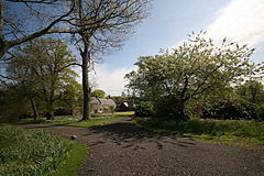
 Geilston House, by Cardross, owned by the National Trust for Scotland | |
| Population | 2,070 (2022)[1] |
| OS grid reference | NS344775 |
| • Edinburgh | 57 mi (92 km) |
| • London | 359 mi (578 km) |
| Council area | |
| Lieutenancy area | |
| Country | Scotland |
| Sovereign state | United Kingdom |
| Post town | DUMBARTON |
| Postcode district | G82 |
| Dialling code | 01389 |
| Police | Scotland |
| Fire | Scottish |
| Ambulance | Scottish |
| UK Parliament | |
| Scottish Parliament | |
Cardross (Scottish Gaelic: Càrdainn Ros)[2] is a large village with a population of 2,194 (2011)[3] in Scotland, on the north side of the Firth of Clyde, situated halfway between Dumbarton and Helensburgh. Cardross is in the historic geographical county of Dunbartonshire but the modern political local authority of Argyll and Bute.
Cardross Village took its name from the historic parish in which it is located and where King Robert the Bruce lived the final years of his life. The Parish of Cardross stretched in area from the River Leven on the west side of Dumbarton to Camus Eskan (near Helensburgh), and stretched as far north to include the village of Renton in the Vale of Leven.
The distinction between Cardross village and Cardross Parish is particularly important for students of Scottish history. King Robert the Bruce's documented association with ’Cardross’ occurred three centuries prior to the existence of the modern-day village, and at a time when the name referred to the ecclesiastical parish and its church, Cardross Kirk.
The original piece of land known as ’Cardross’ is at the eastern edge of the historic parish and the western point of the confluence of the River Clyde and River Leven at the town of Dumbarton, facing across to Dumbarton Rock and Castle. Today the land is known as “sand point” and sits on the edge of Dumbarton's Levengrove Park.[4] The site of medieval Cardross Kirk, and its remains, sits within Levengrove Park.
Etymology
[edit]Cardross is a name of Brittonic origin.[5] The first part of the name is the Brittonic or Pictish *carden, generally meaning "a wild place, a thicket" (Middle Welsh cardden).[5][6] The second is the element -rōs, "moor, promontory" (Welsh rhos).[5] In other words, a thicketed promontory of land.
History
[edit]The settlement of Cardross developed around a 17th-century church. The mother kirk of Cardross Parish was relocated in 1653, 3 miles (5 km) west from its medieval site on the western bank of the River Leven to support a fledgling ferry community on the northern bank of the River Clyde.
Modern-day ‘Ferry Road’ runs the short distance between the A814 and the River Clyde at the easternmost extremity of Cardross Village (closest to Dumbarton).
The new settlement eventually took its name from the church, and the parish that it served, as the 17th-century worshippers headed for the re-located ‘Cardross’ every Sunday.
Today no remains of that original Cardross Village church can be found but the Graveyard is still in use and contains several 17th-century gravestones.[7]
Robert the Bruce purchased the portions of lands of Pillanflatt from the Earl of Lennox, lying on the western bank of the River Leven, Dunbartonshire, in the Parish of Cardross, in 1326. In 1329, he died at the manorial house that he built there.
A field on the bank of River Leven south of the village of Renton, West Dunbartonshire, called the Mains of Cardross, is thought to have been the location of his royal manor, none of which remains today.[8] In 2017, Dumbarton Football Club's proposed new stadium was refused planning permission, with one of the objections being its likely placement on the medieval Bruce site.[9]
Natural history
[edit]Two kilometres (1+1⁄4 miles) northwest of Cardross is a peninsula called Ardmore Point. This privately owned area of land has a nature trail and is considered a Regionally Important Geographical Site (RIGS) due to unique rock formations including an exposed sea cliff.[10] It is a popular fishing and bird-spotting area[11][12] inhabited by grey seals.[13]
Facilities
[edit]Commercial
[edit]There are a number of businesses, including a sawmill, car mechanic, a Co-operative Food Store,[14] newsagents, pharmacy, post office, plumber's merchant, an Indian style take-away, a couple of hairdressers, soap shop and a jewellers.
Ardardan Estate[15] is a working farm with a farm shop, plant nursery and tea room and is situated outside Cardross near Ardmore Point, but closer to the town of Helensburgh.
Sports
[edit]The town possesses a golf course, bowling, tennis and football clubs. Paul Lawrie won the Scottish Professional Golf Championship which was held at Cardross Golf Course in 1992.[16]
Education
[edit]Cardross has its own pre-school and primary school.
Transport
[edit]Cardross railway station has direct links to both Glasgow Queen Street and Edinburgh Waverley stations on the North Clyde Line; the station is operated by ScotRail.
A bus service is provided by First Glasgow.
Tourist attractions
[edit]Cardross is the site of one of the most important modernist buildings in the world[citation needed]. St Peters seminary. Built in the early 1960's.
Geilston Garden, a National Trust for Scotland property, is located on the north west edge of the village.
There is also a ruined church, which was bombed in May 1942 during World War 2. The reason for Cardross being targeted by German bombers remains unclear, locals have speculated buildings in the village might have been mistaken as a shipyard or an oil storage facility.[17]
Religion
[edit]The village has two places of worship: Cardross Parish Church (Church of Scotland) and a Roman Catholic Church dedicated to Saint Mahew. The original parish church was bombed during the Second World War and its ruins are located next to the former Church of Scotland manse.
Listed buildings/structures
[edit]There are nearly fifty listed buildings/structures in Cardross, two of which are category A.[18]
Some structures of note:
- The 14th century St. Mahew's Chapel. Most recently restored in the 1950s as a Catholic church which remains in use.[19]
- The former St. Peter's Seminary, designed by Gillespie, Kidd & Coia, is situated to the north of the village; it is closed to the public. Abandoned in the late 1980s, it is in a state of dilapidation, particularly internally. In early 2015 the site was handed over to the NVA with the intention that part of it will become an arts venue, however those plans failed due to a lack of funding.[20]
- The ruined 15th-century Kilmahew Castle that was built by the Napier Clan is situated just north of the village.
- The main road through the village goes over Moore's Bridge (1688) which carries the road over Kilmahew Burn.
Notable residents
[edit]- Robert the Bruce, King Of Scots, national hero who led Scotland victoriously during the First War of Scottish Independence. Purchased the manor of Cardross in 1325 and made it his primary residence until his death in 1329.
- A. J. Cronin, the celebrated doctor and writer, was born in Cardross in 1896.
- The BBC sports presenter Hazel Irvine lived in Cardross during her youth.
References
[edit]Notes
[edit]- ^ "Mid-2020 Population Estimates for Settlements and Localities in Scotland". National Records of Scotland. 31 March 2022. Retrieved 31 March 2022.
- ^ "Scottish Government Scots Gaelic Translation List" (PDF). Archived from the original (PDF) on 2020-10-13. Retrieved 2018-07-01.
- ^ "Scotland (United Kingdom): Council Areas & Localities - Population Statistics, Charts and Map".
- ^ "Scotland (United Kingdom): Council Areas & Localities - Population Statistics, Charts and Map". www.citypopulation.de. Retrieved 2021-07-28.
- ^ a b c James, Alan. "A Guide to the Place-Name Evidence" (PDF). SPNS - The Brittonic Language in the Old North. Archived from the original (PDF) on 13 August 2017. Retrieved 25 November 2018.
- ^ "Place Names - C - E" (PDF). The Scottish Parliament - Pàrlamaid na h-Alba. Archived from the original (PDF) on 13 October 2020. Retrieved 2 February 2019.
- ^ "Cardross Visitor Guide - Accommodation, Things To Do & More". www.visitscotland.com.
- ^ Strathleven Artizans: Robert the Bruce King of Scots
- ^ Donald, Carla (27 June 2017). "Dumbarton FC's new stadium in jeopardy because of Robert the Bruce links". dailyrecord.
- ^ The Geology of Ardmore Point
- ^ "Google". www.google.com.
- ^ "Clydebirds". Clydebirds. Archived from the original on 2012-01-27. Retrieved 2011-11-03.
- ^ "Ardmore Point, near Helensburgh". Walkhighlands. Retrieved 2011-11-03.
- ^ "Main Road - Cardross Co-op, Main Road, Dumbarton, G82 5PD". Co-op Food store finder - back to being Co-op.
- ^ Ardardan Estate: Welcome to Ardardan
- ^ Cardross Golf Club Web Site
- ^ "Memories of the Cardross Blitz". www.helensburgh-heritage.co.uk.
- ^ List of listed buildings in Cardross, Argyll and Bute
- ^ "The Chapel of Saint Mahew, Cardross - St. Mahew". www.stmahew.rcglasgow.org.uk.
- ^ "Preserving Scotland's modernist ruin". BBC News.
Sources
[edit]- "Ardardan Estate: Welcome to Ardardan". Retrieved 31 December 2010.
- "Strathleven Artizans: Cardross". Archived from the original on 20 January 2011. Retrieved 31 December 2010.
- "Area Profile of 46 Ward Cardross (Argyll and Bute 2001 Census Factsheets)". Archived from the original on 2007-09-28.
- "The Geology of Ardmore Point" (PDF). Archived from the original (PDF) on 9 June 2011. Retrieved 31 December 2010.
- "Strathleven Artizans: Robert the Bruce King of Scots". Archived from the original on 11 November 2010. Retrieved 31 December 2010.
- "Hermitage Academy web page". Archived from the original on 2007-10-10.
- "Cardross Golf Club". Archived from the original on 2008-05-11.
- "Historic Scotland's Statement of Significance for St. Peter's" (PDF). Retrieved 31 December 2010.


